Arizona's Changing Rivers: How People Have Affected the Rivers
Barbara Tellman, Richard Yarde, and Mary G. Wallace (1997)
This publication does not bemoan losses of the past or pass judgment on the value of pristine rivers versus the forces of change. Rather, the purpose is to try to understand what caused the many changes that have occurred. In some cases, most people agree that mistakes were made that led both to changed rivers and to other problems for humans. In other cases, tradeoffs were made. A flowing river became a lake or a dry streambed in exchange for millions of dollars worth of crops or cities that house millions of people. Whether the tradeoffs were worth it is a value judgment. (3)
Chaco Canyon in northwest New Mexico was the leading trade center for a large area extending into central Mexico. Traces of trade routes extending for miles from Chaco still can be seen. Anasazi architecture required the use of thousands of wood beams. More than 200,000 beams were used in multi-storied pueblos in the canyon. Over the years people had to go farther and farther from home to find big enough trees. Chaco Canyon residents deforested the area for miles around, leading to erosion, more damaging floods, arroyo cutting, and loss of good farming soil. This probably contributed to the settlement being abandoned at the end of the 12th century. The Anasazi in other areas increased their use of check dams, reservoirs and irrigation and were temporarily able to feed and house a growing population in the face of disasters in Chaco and elsewhere and were able to prolong their way of life for another century or so. (9)
Some archaeologists believe that when the Chaco civilization failed in the north, its trading partners (especially the Hohokam) also suffered, contributing to the decline of their way of life. Other archaeologists believe that the amount of governmental control needed to maintain the complex irrigation systems of the Hohokam led to revolt of the "working classes." Some wonder if the spread of European diseases such as small pox reached Arizona even before the Spaniards themselves did, which caused people to die of new diseases to which they had no immunity. Even if this were true, the societies were already in decline. Some scholars, however, believe Hohokam civilization lasted into Spanish times. (10-11)
In 1929 Omar Turney published an exhaustive survey of the ancient canals and other structures, looking at ruins, reading old descriptions and talking with people who had themselves knocked down buildings or plowed over canal systems. His map had enough canals to account for 200,000 irrigated acres and up to 250,000 people. Later researchers put the acreage at up to 400,000 acres, not all of which would have been farmed at the same time. The most recent estimates are that between 100,000 and 200,000 acres were farmed through 185 miles of canals. The maximum population was between 50,000 and 200,000. (11)
The Hohokam would have collected and cut wood for their fires and homes. In many cases they probably left vegetated strips between fields and harvested by cutting branches rather than taking whole trees. Before the introduction of electricity, the Anglos harvested wood extensively and cleared whole forests, leading to erosion and loss of soil which changed the rivers. (12)
The years after the early twentieth century drought were particularly wet ones, when Colorado River flows of more than 15 million acre-feet were common. Using those recent flow records, the water of the Colorado River was divided between the Upper Basin states (Colorado, Utah, New Mexico and Wyoming) and the Lower Basin states (California, Arizona and Nevada), with upper and lower basins each allocated 7.5 million acre-feet annually. If negotiators had the tree ring records when they calculated river flow in the late 1920s, they probably would have allocated far lesser amounts. A drought as long as the one in the sixteenth century probably will again affect the river. (14)
[Arizona Daily Star, May 6-7, 1887:
Tucson Gets an Earthquake.
Buildings Rock Like Ships at Sea.
"... It was only a moment until the streets were filled with terror stricken people .... The court house dome moved back and forth like a tall tree .... great slices of the [Catalina] mountains gave way and went tumbling down into the canyons, huge clouds of dust or smoke ascended into the blue sky, high above the crest of the queenly mountain
Great boulders or little mountains, wrested from their seats by the shock came thundering down into the valley .... [May 4]
" ... A peculiar feature of the earthquake ... in the Sulphur Springs Valley ... was the opening up of hundreds of water veins .... the dry parched earth beneath our feet was opening up in every direction around us and water was spurting up in some places as high as 10 feet above the surface .... " (15)
In relatively recent times, the state also has experienced natural geological events including an earthquake and a volcanic eruption. In 1066 AD, Sunset Crater, in northern Arizona, erupted. It caused short-term devastation, but also spread a layer of rich ash over the landscape which conserved soil moisture and increased the agricultural productivity in the area.
Another dramatic geologic event was the earthquake of May 3, 1887. Its epicenter was located just south of the border near San Bernardino Ranch in southeastern Arizona. It was about as powerful as the San Francisco Earthquake of 1906. The quake damaged many of the buildings in St. David and elsewhere in the San Pedro Valley, including the remains of the abandoned town of Charleston. It also caused swamps and cienega areas in the St. David area to disappear. Many existing and newly-dug wells began to flow under artesian conditions. In fact, artesian wells in the area were first discovered in the 1890s when water flowed temporarily from a ground fissure opened up by the great earthquake. (15)
The Santa Cruz River once was mostly perennial from its headwaters in the San Rafael Valley, through Mexico and north to about Tubac, often as a series of cienegas rather than a flowing river. At Tubac the geology changes, and the water went underground surfacing near the mission of San Xavier del Bac outside of Tucson. After a short perennial reach, the river was often a dry streambed until it surfaced near Tucson's "A" Mountain. Springs from San Xavier to Rillito Creek created cienegas and added to the flow. The last dependable water was at the Nine-Mile water hole at the north end of the Tucson Mountains.
From there, springs or waterholes were the only water available until the Gila River. The trail in Pinal County was called the "Ninety-Mile Desert." The channel in the area was for the most part insignificant, except during floods, and many old maps showed the river ending in the desert miles before the Gila River. (17)
The Santa Cruz River Valley is broad and fertile, with moderate winter temperatures. It is not surprising, then, that the valley attracted farmers, starting as early as 1200 B.C. Stable farming communities were in the Santa Cruz Valley by at least 600 B. C.
These early Hohokam farmers grew corn, tobacco, and possibly cotton and agave. The crops were raised during the rainy season or were irrigated with surface waters from the Santa Cruz River, diverted through ditches. The Hohokam ate fish caught in the river. (17)
"Today we passed through Tucson. Here we heard some awful tales of the route ahead of us [from Tucson to the Gila], dead animals strewing the road, wagons forsaken, human skeletons, who had famished for want of water etc." W. Hunter, 1849 (19)
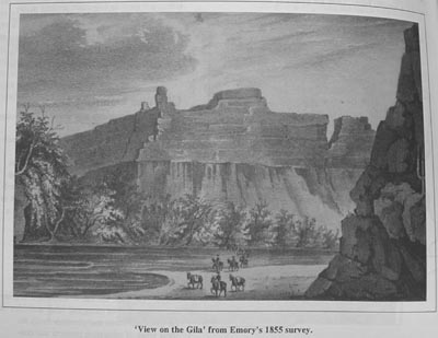
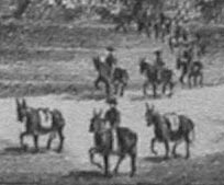
William H. Emory's View on the Gila (1855)
|
I realize Emory was a landscape artist, so he probably didn't care about the figures (that's what they always say about Hitler's architectural sketches). Or maybe he figured viewers would be so overawed at the scenery they wouldn't pay much attention to the figures (who, like Wagner, were there just "for scale").
|
|
What's funny is that Emory drew all the horses in the same pose: heading right to left, with the horse's right foot nid-step, as if he were using toy horses for models but had only one.
Or maybe he learned only the one method of drawing horses and it served him throughout his career. A workhorse method, if you will.
|
|
|
Mexico went to war with Spain and gained independence in 1821. After the U.S. defeated Mexico in 1848, Mexico retained the Santa Cruz Valley temporarily. Soon after the 1849 California Gold Rush, the United States purchased all of southern Arizona south of the Gila River (The Gadsden Purchase), or most of the Spanish frontier of Pimeria Alta. So, just as minerals were becoming scarce in California, a huge new land mass was added to the American domain. (19)
Although the Santa Cruz River Valley passed from Spanish to Mexican to American ownership, settlement in the area was retarded by persistent Apache raids. It was not until well after U.S. purchase of southern Arizona, in fact not until after the Civil War ended in 1865, that a military presence allowed relatively safe settlement of the valley. (21)
Once the human population began to grow, many species were pushed out of the area. The large herbivores, or plant eaters, like antelope, were not welcome in farmlands and were hunted. Some of the large predators like grizzly bears and wolves are no longer found anywhere in the valley. Others became limited to upper elevations. Even now a hiker in the mountains near the Santa Cruz might be lucky to catch a glimpse of a black bear or mountain lion. (24)
The three centuries following the Spanish and Athabaskan migrations into Arizona were unstable times. The Spanish introduced new diseases that often devastated whole communities. The effect of disease was probably compounded by the Spanish system of gathering native peoples into population centers, where disease spread rapidly. Nomadic tribes were less affected. (28)
The Apaches had some effect on the rivers, especially through their technique of using fire to keep some areas as grass land rather than mesquite-shrub dominated landscapes. But their greatest influence was through keeping sedentary peoples out. Apache raids rendered much of the San Pedro and Santa Cruz valleys uninhabitable for ranching and farming for about two hundred years, postponing the effects of overgrazing and heavy water use until the Anglo-Americans prevailed at the end of the nineteenth century. (28)
Wood was needed for mining activities, and for personal heating and cooking. So much wood was cut that the area was denuded of trees, from mesquite bosques along the river to upland trees. After residents cut all the available trees near Tombstone, they went further afield to the Huachucas, Whetstones, and other mountains. The impact on the vegetation was immense. Tombstone alone is estimated to have used 120,000 to 130,000 cords between 1879 and 1886. If this wood were stacked four feet high in four-foot lengths it would reach almost 200 miles. (34)
The people here in Arizony
All look very pale and bony.
They shake and ache and burn and shiver
Up and Down the Gila River.
I'm freezing in the heat of day,
I feel like winter's here to stay.
I'm too cool for the month of June,
So bring me quinine and a spoon. . ."
—Old song, sung to the tune of "Old Dan Tucker"
The Colorado River formed a barrier to exploration for most of its length in Arizona. Travel through the Grand Canyon by foot or mule was very difficult (although Indians had traveled there for centuries), and boat travel was risky. There were only two good crossing spots to the north—Lee's Ferry and another near what is now the Page area. There were about a dozen ferries and crossing locations around and south of the present Lake Mead down to Yuma. The Colorado River is the only Arizona river on which boats regularly traveled—and such travel ceased by the end of the nineteenth century, except for recreational boating. Even though travelers no longer are dependent on rivers for drinking water, many of today's major transportation routes, such as 1-10, still follow the historic trails and roads.
To cross the state from the east in the nineteenth century, most travelers either followed the Gila River, entering Arizona about where I-10 is today, or they traveled south of the Chiricahua Mountains, crossing the San Pedro River and then traveling up the Santa Cruz River. The southern route was longer than the northern route, but had the advantage of avoiding much of the Apache danger. A northern route left the New Mexico pueblos and met the Zuni and Little Colorado rivers, then headed west by either of several routes. Another route skirted Arizona, going through Utah and down along the Virgin and Colorado rivers.
Travelers adversely affected rivers on the more common trails. Wheeled vehicles rutted the roads, causing gullying and erosion. Firewood near the stopping places was gathered and trees were cut. Livestock trampled the shores at waterholes and river crossings, especially when many animals traveled together. Livestock also ate whatever vegetation was available. This left the river vulnerable to erosion and more devastating floods.
In some areas so little vegetation was left near the trails that cattle starved. By the time travelers reached areas with vegetation, their livestock were ready to eat less palatable kinds of plants. When travelers were few and far between, or parties were small in number, the long-term impacts to rivers were small. On the more-traveled trails, however, the impacts could be significant, especially at major crossing points. (40)
Many modem highways approximately follow the old trails. I-10 follows the old trails (north of Apache Pass) along the Gila River west to Casa Grande, with a curve south to Tucson. I-8 resumes that trail all the way to Yuma. I-19 parallels old trails from Tucson to Nogales. In the north, I-40 follows the routes of travelers from Santa Fe west. The old trail around the Guadalupe Mountains east of Douglas has been abandoned, but parts of it have become highways 80 and 82. Old trails from Prescott west and south and through Wickenburg are now highways. Most of the roads going through Phoenix are recent since the city was not on most older routes. North-south travel from Flagstaff is also relatively recent, as is the Salt River route through Globe. (42)
Between 1605 and 1850 no foreign expedition entered the Middle Verde Valley. Probably the most lasting impact of the Spanish was the introduction of horses, which changed the lifestyle of the Apaches. Horses made them more mobile and allowed them to roam farther. (44)
Americans again entered the Verde Valley—this time to mine gold, silver, and later copper. From the beginning there were major conflicts between the Yavapai and Apaches accustomed to hunting over a very large region, and American settlers who claimed many of the best areas (always near water) for their own. After the Civil War, the military arrived to protect miners and settlers. (45)
American settlers moved to the Verde Valley in the 1860s and soon were making a living selling food to the miners and soldiers. The first large agricultural ditch was dug by hand with crude tools in 1874 by the Yavapai who by then had a reservation along the river. After one good crop year, the Yavapai again were relocated, and American farmers took over the successful ditch. (46)
Also in the 1960s the U.S. Forest Service implemented a major watershed clearance project on the Beaver Creek watershed. The plan was to rid the area of trees by mechanical removal as well as the use of herbicides. Some of the herbicides used were highly toxic, but the U.S. Forest Service did no monitoring, so long term impacts on other vegetation, wildlife and humans are unknown. (48)
Uranium mining was important in northeastern Arizona in the 1950s and 60s. The mines resulted in short-term pollution problems from radioactive materials, especially along the Rio Puerco. Health problems now plague Navajos who worked those mines. (53)
In areas such as the Santa Cruz Valley, the combination of urban and agricultural water use dealt the final blow to the river, which finally ceased to flow regularly sometime in the 1940s. (55)
Few Indians were living in the Salt River Valley when pioneer settlement began in the 1880s. Pioneers encouraged Pima Indians to move from the Gila River to area north of the Salt River to help serve as a buffer against the Apaches, When the Gila River began to dry up because up-stream farmers were using so much water, other Pima Indians migrated to the Salt River Valley which still had water for farming. Later, when competition for farmland and water increased, settlers harassed the Pimas and tried to remove them from the area. (60)
Nineteenth century travelers described the ponderosa pine forests of northern Arizona as open and park-like, with large trees widely spaced. Lush grasses provided good grazing for wildlife and later cattle. The same forests today tend to be dominated by many small trees closely spaced. In one area, for example, where the number of trees in pre-settlement times was under 60 per acre, the present density is over 275 per acre. In another area the presettlement density was less than 25 trees per acre, while the current density is over 850 per acre. In such areas the number and variety of other plants is much less, leaving less browse and grass for wildlife.
The vegetation changes now favor species that feed in dense forests (such as the Abert squirrel) over those that feed in grasslands (pronghorn antelope and turkeys). Closely packed trees use more water, leaving less for streams. The reasons for these changes are complex, including overgrazing, fire suppression, logging, and road construction. The combination of all these factors has resulted in forests much different than those of 150 years ago. (74-5)
The Vulture Mine's legacy was years of litigation, as many different interests tried to claim the rights to its gold. After all, it was worth fighting for—it produced over $15,000,000 in gold during its century of on-again, off-again production. It wasn't worth it to Henry Wickenburg, though. Wearied by the litigation and the loss of much of his property to the Walnut Grove Dam collapse, he trudged on to his eighty-eighth birthday in 1905. And at sunset on his eighty-eighth birthday, at the same spot on which he had first camped when he came to the banks of the Hassayampa, Henry Wickenburg was found dead, a pistol in his hand and a bullet in his brain. (81)
In the final decades of the 19th century, arroyos suddenly appeared throughout the Southwest. Some of these arroyos were in rural areas such as along the Little Colorado and the Verde rivers, while others were in more urban areas such as Tucson. Arroyos also appeared in many areas within the neighboring states of New Mexico and Utah. They appeared over a period of about 20 years, with most forming from 1885 to 1900. Many arroyos fanned suddenly during a single severe storm. (88)
Where subdivisions replaced farmland in the Salt River Valley water use remained the same since farms and suburbs use roughly the same amount water. When suburbs replaced desert, however, water demand often increased. (92)
The Hohokam inhabited the central part of the Gila River Basin and began to form community groups beginning before 800 A.D. Communities were located along the mainstem of the Gila River. By the mid-eleventh century more than 250 communities were in the watershed.
One large Hohokam population center was Snaketown, at the confluence of the Salt and Gila rivers. Another large community, Casa Grande, was on the south bank of the river near present-day Coolidge. Here, the Gila flowed perennially, except in drought years. One main canal diverted water from the river, and a series of irrigation canals brought water to the fields. (97-8)
In 1825 the Patties were among the first Americans to enter the area, trapping beaver. Beaver were plentiful. Pattie noted of the river he called the Helay, that "At this point we commenced setting our traps. The river here was beautiful, running between banks covered with tall cottonwoods and willows." He also found other wildlife, such as otters, turkeys, antelope, mountain lions, and javelinas. (98)
In 1863, the Pimas, who lived downstream of San Carlos, sold over 700,000 lbs. of wheat to the government and traders. By 1868, white settlers used so much of the water that the Pimas in dry years had to leave the reservation or starve. From 1869 on, the Gila River Reservation suffered from a scarcity of water. A drought later worsened the water shortage.
The San Carlos Irrigation Project, including Coolidge Dam 65 miles upstream of Florence, was proposed, in part, to deal with this problem. Built in 1929, Coolidge is the only large storage dam on the river. However, this dam has never lived up to its promises. It was supposed to create a lake 25 miles long and three-miles wide to provide water for 100,000 acres of land, one half for Indians, one-half for non-Indians. For many years, the dam never retained much water, usually forming only a large muddy pond behind the dam. When it was dedicated in 1930, Will Rogers remarked, "If this was my lake, I'd mow it. " (102)
A non-scientific description
''The body is as large as a flour barrel, five feet up it forks into four stems, the whole highth [sic] is not less than 20 feet. Take a bundle of rods, 2 inches in diameter, tie them together, paint a delicate green, stick some pins, point outward in the center of each rod the whole length, and you have a pretty good idea of this species of cactus
One of the stems was broken off, the whole tree looked as if the slightest wind would blow it down." James Bell, 1854. (129)
Hot deserts are only one of Arizona's many faces. In contrast, the northern part of the state has mountains that provide a completely different environment, a different face. Southern Arizona also has mountains. A series of separate mountain ranges stretches south of the Gila River, from west of the Santa Cruz River to the New Mexico border. These "sky islands" are forested and relatively cool and moist at the higher elevations. The riparian areas that extend from these mountains into the desert act as corridors for traveling wildlife. Less mobile animals, though, have remained relatively isolated by a sea of desert over geologic time. Sky islands act as harbors for many species, some that cannot be found anywhere else on earth. Plants and animals in these remnant habitats are particularly sensitive to disturbance. (130-1)
"Ours has been the first, and will doubtless be the last, party of whites to visit this profitless locality [the Grand Canyon]. It seems intended by nature that the Colorado River, along the greater portion of its lonely and majestic way, shall be forever unvisited and undisturbed." Joseph Ives, 1861. (147)
|